Clouds will impact Total Solar Eclipse in Central Texas
Rounds of severe storms post Eclipse into the middle of the week
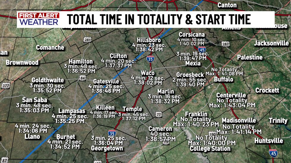
The excitement is building in across Central Texas this weekend as the countdown to the Total Solar Eclipse continues! During the eclipse, most of us are going to get about four minutes of totality, which is pretty awesome! Totality starts around 1:34 PM in our southwestern areas and a little later near 1:40 PM near I-45. We’ll get into your eclipse forecast in a little bit, but there’s something else you need to have on your mind for AFTER the eclipse. Central Texas has an active stretch of weather for the first half of the work week. Late Monday into Tuesday and Wednesday could get interesting, with some strong to severe storms possible for our area. All modes of severe weather look possible - including large hail, gusty winds, and maybe even a tornado or two. You’ll want to be weather aware starting Monday afternoon (after the eclipse), Tuesday, and possibly even Wednesday morning. There’s also been an increase to the flooding potential in Central Texas as 1 to 3 inches could be possible into the new week. We are in our severe weather season here in Central Texas, so the benefit of rain also comes with the risk of severe weather. Make sure you have reliable ways to get weather alerts if/when they happen in your area. Our free KWTX weather app is a great tool to have in the upcoming days with the risk of severe weather AND you can find the most up to date eclipse forecast there as well.
Before we get into Monday’s Total Solar Eclipse forecast - the weather on Sunday looks to be pretty nice. There’s a quick shot for a few showers late tonight into early Sunday morning as a Pacific front slides through, but most will miss out on rain in our area. Drier air is set to slide in behind the front - Allowing for more sunshine to return for all those outdoor eclipse events happening across Central Texas Sunday. Sunday morning starts out in the 50s to low 60s with highs jumping back into the upper 70s to low 80s for the afternoon. Winds will be a little breezy throughout the day, but not as strong as they were on Saturday. Our weather quickly changes Sunday night thanks to a warm front bringing back breezy southeast winds, which will pump in that higher humidity air and more cloud cover… And that cloud cover will be impacting our views for the Total Solar Eclipse on Monday.
Now, unfortunately, your eclipse forecast is looking unchanged in that we will have cloud cover around during the event - But there are still a lot of unknowns that we’ll have to sort out on Sunday and even into Monday morning in regards to our viewing of the eclipse. Cloud cover is very tricky to forecast, and sometimes, models do not have a great idea on what will happen until things are unfolding. Here’s what we know: Cloud cover WILL be around on Monday. The TYPE of clouds plays a huge role in what we’ll be able to see come the Total Solar Eclipse. Right now, high level clouds look likely for much of the state of Texas, but thanks to that warm front bringing in more low-level moisture, low level clouds will be on the increase Sunday night into Monday morning. Any amount of clouds impacts what we’ll be able to see during the eclipse. High level clouds can block the sun, but depending on how thick the coverage is, some of the eclipse may still be visible. Low level clouds make it hard to see the sun as they completely block it. These are the clouds that we’re forecasting to be on the increase from south to north throughout Monday morning… How far north those clouds get in time for the eclipse is something we are unsure of right now. Now, low level clouds can also erode as the sun warms up the atmosphere - Which is something we will have to watch day of. There’s still a possibility that those clouds could break up, allowing for some opportunities to witness the Total Solar Eclipse. IF the clouds break up throughout the morning hours, that would be the best scenario for viewing the eclipse. If the clouds are remaining put and not eroding by lunchtime, they’ll likely stick around for the entire event, preventing us from getting a good view of the moon crossing in front of the sun. AFTER the eclipse Monday afternoon and evening, an approaching storm system out west will begin to slowly march its way eastward, increasing the shower and thunderstorm potential for Central Texas. Numerous rounds of active weather is likely for our area starting late Monday afternoon and again late Tuesday into Wednesday as a cold front moves through.
Copyright 2024 KWTX. All rights reserved.


