Scattered Showers This Afternoon, Cooler Temperatures Next Week
Scattered showers and thunderstorms are pushing their way across Central Texas once more this afternoon, with the heaviest storms along and east of the I-35 corridor. Good news is, a lot of these storms are sub-severe, so you can expect a few heavy downpours as well as some gusty winds with these thunderstorms, but severe weather is NOT expected. These showers will continue to linger across the area and remain hit or miss (aka, your neighbor might see rain, but you might not) until late tonight. The rain chances will return again on Friday, but not quite in the capacity that we are seeing today or even yesterday for that matter. Temperatures remain in the mid 90’s and Central Texas will dry out and warm up slightly heading into the weekend!
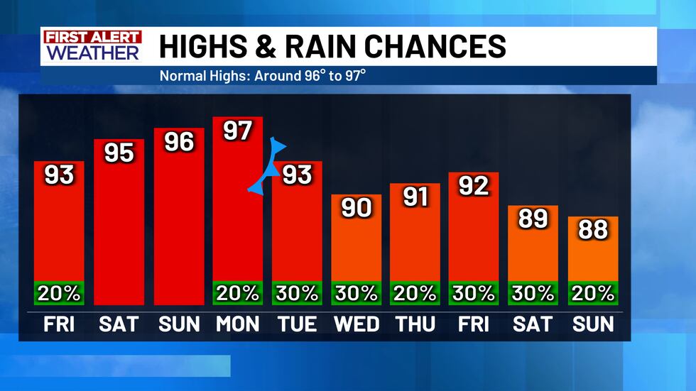
Some changes are still in the First Alert Forecast for next week. Another “cold” front is expected to move in between Monday and Tuesday, which will most likely dip our temperatures back into the low 90’s and maybe even into the upper 80’s in some cases! This is not the only change though - the cooler weather will be accompanied by more isolated to scattered rain chances, from Monday all the way into Labor Day weekend. Much like the front from this week, next week’s front will provide just enough lift for any moisture in the area to become an isolated thunderstorm and precipitate. As of now, rain chances aren’t that high (roughly 20% to 30% on any given day) but we will continue to update this through the weekend.
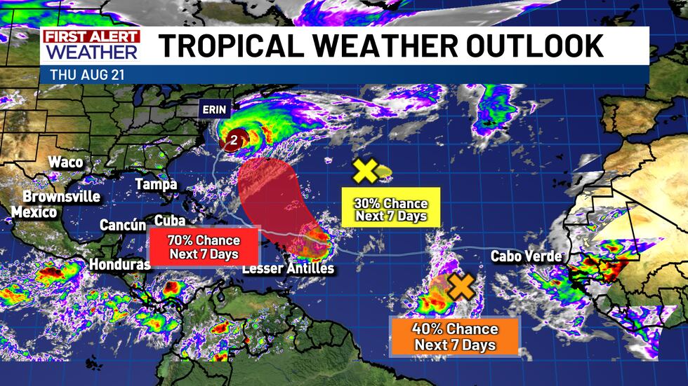
The tropics continue to remain active, as Erin is now more than halfway up the east coast, and more tropical waves continue to develop. there are at least three different waves in the middle of the Atlantic - one with a high chance, one with a medium chance, and one with a low chance of development. None of these waves are a concern for the Gulf or even the U.S. mainland for that matter. Just keep an eye on the temperatures and the rain chances for the next week and that should be more than enough to keep you prepared in the near future!
Copyright 2025 KWTX. All rights reserved.


