Strong cold front tonight brings Freeze Watch Sunday night
quick surge of late fall chill
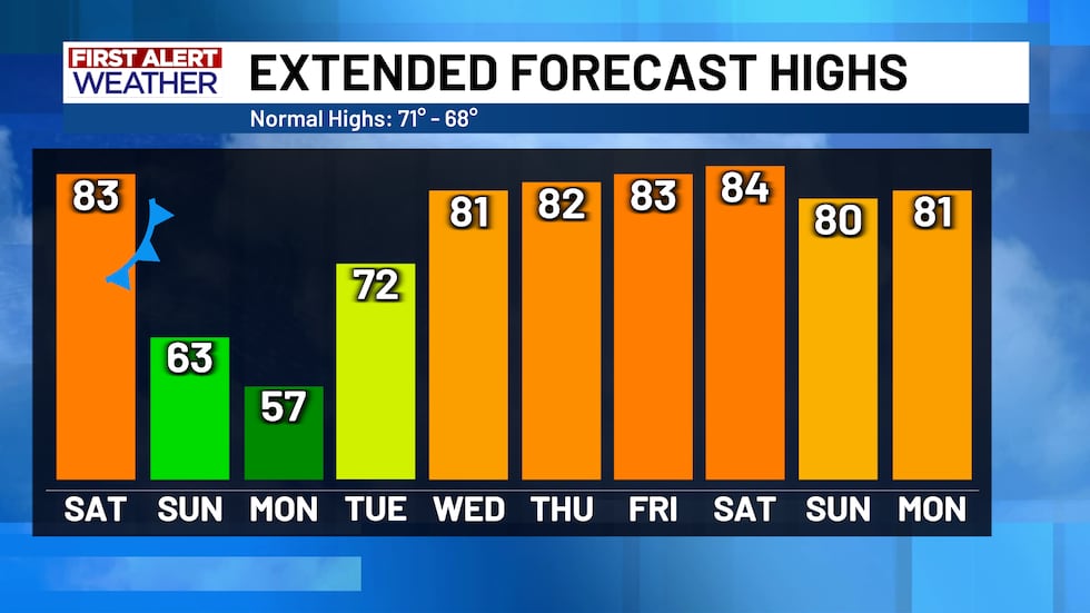
A strong cold front is moving in tonight, and it’s going to feel much colder by Sunday. Temperatures will drop well below normal, and most of Central Texas will be expecting freezing temperatures Sunday night — which is why there’s already a Freeze Watch in effect for over half of Central Texas.
Before the front arrives later today, we’ll actually warm up quite a bit with highs in the low 80s. The front expected tonight doesn’t come with any rain chances but it will help to usher in the coldest air we’ve seen so far this fall season.
Once the front hits, you’ll notice a difference. Winds will turn strong and gusty out of the north, up to 35 mph, and Sunday will be about 20 degrees cooler than today, with highs in the low 60s. Those strong, northerly winds will make it feel colder with the “feels like” temperatures stuck in the 50s tomorrow.
Today is a good day to prep for the cold because by Sunday night into Monday morning we can expect widespread freezing temperatures. Winds will calm down by then, so wind chills won’t be much lower than the actual temps. Temperatures will be in the 30s again Tuesday morning, but expected to be above freezing by a few degrees.
After that cold start to the week, things gradually warm back up. By Tuesday, winds shift back to the south, and highs climb to near or above normal for the rest of the week. It’ll stay dry, though, with no real rain chances until maybe next weekend at the earliest.
Copyright 2025 KWTX. All rights reserved.


