Gray sky, cold days: light rain returns tomorrow
Cold north winds are still pushing much chillier air after yesterday’s front. These strong, north winds keeping it feeling even colder throughout the day. Clouds will hang around, and highs will only reach the low to mid-40s, but feeling like the upper 30s/low 40s. North winds stay breezy through early afternoon before easing this evening.
Another weak disturbance moves in Monday, bringing increasing clouds and a small chance of light rain. Temperatures will be too warm for wintry weather. Light rain or drizzle may linger into midday Monday, with temperatures staying in the 40s. The best chances for rain will be for areas along and east of I-35.
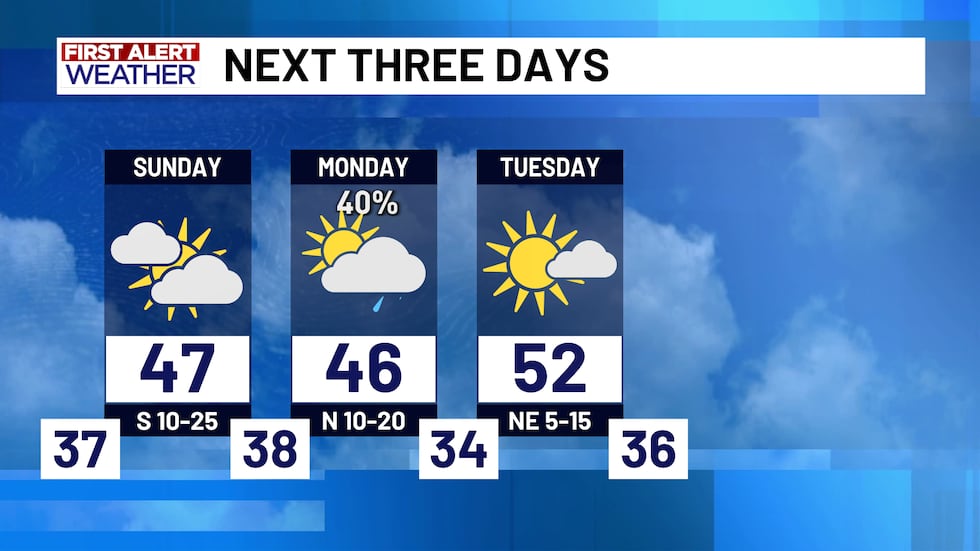
After Monday, we’ll start a gradual warm-up. Highs climb back into the 50s and 60s by midweek. Another front is expected sometime late Wednesday or Thursday, but models still disagree on timing and how cool it gets. Rain chances also look to return with Gulf moisture streaming in. As of now, models disagree on how much rain we could see. Late-week temperatures depend on how quickly that front moves through. Lots could change with the front on Thursday, so stay tuned for updates through the early part of the workweek.
Copyright 2025 KWTX. All rights reserved.


