Warm, breezy, & wildfire concern today followed by brief cool down
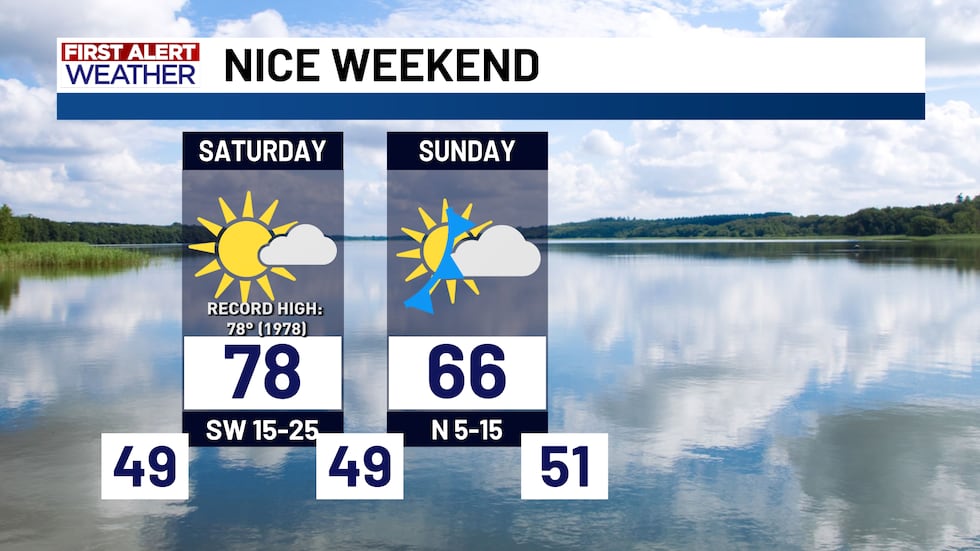
There’s enough warmth to challenge — or even break — the record high for today as the warmth builds in. The warmth is coming from southwest winds bringing in warmer air from West Texas, plus some extra heating as a weak cold front approaches. Highs today make it into the upper 70s and low 80s. It’s warm today but a cold front moves through this evening, bringing temperatures down once again for Sunday.
Tomorrow will feel much more like winter, with a mostly cloudy sky and highs in the 50s and 60s. It’ll cool things down overnight, with lows dropping into the 40s and 50s. Cooler air sticks around through Sunday, with highs only in the 60s — a fitting start to winter. Expect a mostly cloudy sky, making it a good day to bundle up with a hot drink.
By Sunday night, the cooler air starts retreating north. Southerly winds return Monday, quickly warming us back into the 70s, and by Tuesday, some areas west of I-35 could see highs back in the 80s.
Rain isn’t in the forecast anytime soon, and temperatures should stay pretty steady through the week. It looks to be a warm Christmas, with highs in the upper 70s to low 80s. Looking ahead to the very end of the year, there are hints of a possible pattern change by next weekend. Confidence is low on which way it could go, so stay tuned as we forecast for the final few days of 2025!
Copyright 2025 KWTX. All rights reserved.


