Sweet, sweet heat relief is arriving! Tomorrow...
Y’all probably want fall weather to move in today and who could blame you since we’ve had mid-summer heat for the last about two weeks. It might be hard to practice some patience with high temperatures in the upper 90s being joined by a boatload of humidity, but true fall-like weather is ushered in tomorrow as a cold front pushes through.
Today’s weather is same ol’, same ol’, but unfortunately that means it’s still going to be dangerously hot and humid. The yuckiness this morning turns to oppressive heat this afternoon with sunny skies sending temperatures into the mid-to-upper 90s! In addition to seeing highs approaching 10° above average, humidity in place ahead of tomorrow’s storm system will send heat index values to as high as 105° this afternoon. It’s highly unlikely that we’ll see any rain during the daytime hours, but there’s a chance for a stray shower or two in Milam, Robertson, and Leon County. There’s also a chance that a rogue thunderstorm could break off from our approaching cold front and impact parts of Mills, Hamilton, Bosque, or Hill County between roughly 8 PM and 1 AM, but this chance is low.
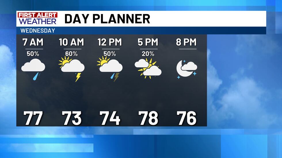
Tomorrow’s cold front pushes through mostly during the daytime hours and ushers in some amazing weather for the remainder of the work week. Tomorrow, though, will be a soggy one! We’re expecting scattered rain to develop as early as about 2 AM Wednesday but will most likely develop a bit before sunrise. Widely scattered to numerous showers and thunderstorms are expected to form and slowly push through during the day. The most likely time frame for rain will be from roughly 8 AM to around 2 PM with the most widespread rain likely between around 9 AM and 12 PM. A few storms could be on the strong side and bring gusty winds and up to quarter-size hail, but the severe weather prospects on Wednesday aren’t high. Rain should gradually come to a close during the afternoon from north to south, but cloudiness may linger for a few hours after the rain ends. By sunset, we’re all dry but most should be dry by the evening rush out. With tomorrow’s front arriving pre-dawn and pushing through during the morning, our temperatures will be a bit wonky!
Ahead of the rain, morning temperatures will likely be in the upper 70s and could potentially even still be in the lower 80s in spots! When rain starts, we’re expecting temperatures to drop into the low-to-mid 70s and likely stay there throughout the day. When the rain comes to a close late-day, those that see sunshine could maybe have temperatures rebound back into the upper 70s and lower 80s, but many of us will stay in the 70s throughout the day. There could even be a few upper 60s late-day if rain is still falling in your neighborhood!
I want to mention that there’s a chance that tomorrow’s cold front comes through a bit faster than the upper-level support for showers and storms arrives. If that were to happen, our rain chances will drop significantly and most of us may stay dry. We’ll still get a temperature drop, but it might not be as drastic as what we’re anticipating.
After tomorrow’s front clears the area, break out your party gear; it’s finally going to feel like early fall and for quite some time too! We have no big storm systems moving toward Texas after Wednesday, and we thankfully are not seeing signs that high pressure will build and bake us again. In fact, afternoon highs stay close to and maybe even a little below average every day from this Thursday to next Thursday settling each day in the mid-to-upper 80s. Your party gear may actually need to include a light jacket or hoodie in the morning as morning lows dip into the low-to-mid 60s every day. There could even be a few upper 50s out there too! Finally, it’s that time of the year where you’re putting on the heater on for the morning commute and the A/C for the drive home.
Copyright 2025 KWTX. All rights reserved.


