SOON!
In fact, very soon! If you’re looking for a drop in temperatures, you won’t have to wait long as two cold fronts are set to push through over the course of the next week. Even though the first front won’t arrive until Saturday, there’s going to be a noticeable change in the weather that you’ll probably enjoy; get ready for extra clouds heading our way!
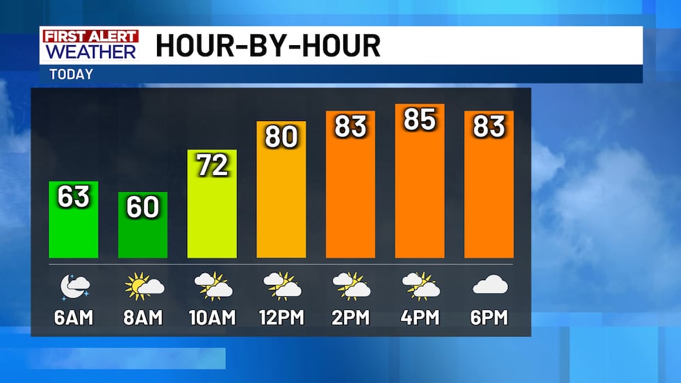
The extra cloudiness today is perfect to help to cool us off. An upper-level trough of low pressure moving into South Texas is pulling moisture in from the Gulf (which leads to maybe a few rain chances Friday and Saturday), but is going to help to obscure the sunshine for much of the day today. Skies start out mostly clear this morning with some clouds moving through east of I-35. We’re starting the day cooler than yesterday, but not by terribly much. We’re out the door in the upper 50s and lower 60s with late-day temperatures only warming into the mid-80s as those clouds arrive. No precipitation falls from those clouds today, but the rain chances will go up (just a lil’ bit) tomorrow and Saturday.
Expect today’s clouds to move out of the area overnight tonight, so warmer weather is in our future tomorrow. Extra humidity that’ll move in behind southerly winds means we’re out the door with low-to-mid 60s. Later in the day, the abundant sunshine will boost highs back into the mid-to-upper 80s. If there’s to be rain tomorrow, the best chances will be east of I-35 between about 4 PM and 8 PM. Some impacts to Friday night football games are possible, but most should stay dry. South winds may make it a bit difficult for those placekickers Friday night! We’ll see south winds gust to near 20 MPH ahead of Saturday’s front.

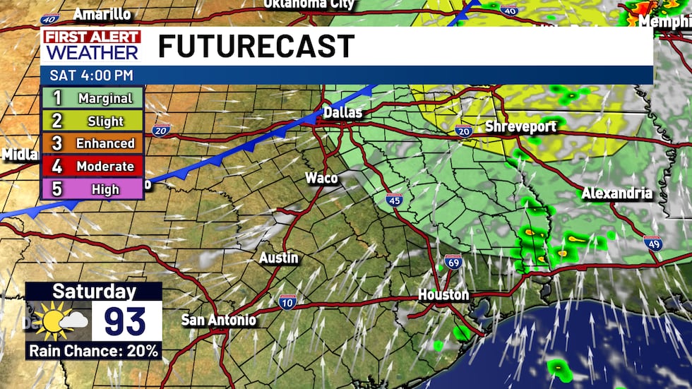
Saturday’s cold front will likely come through mostly dry, but we will have to monitor for a stray stronger storm or two Saturday afternoon. Overall rain chances are near 20%, but any storm that forms late-day could potentially strengthen to include some gusty winds and hail. The main severe weather threat, which is at a level 1 of 5 on the severe weather risk scale, is primarily for the I-45 corridor. Otherwise, you may not notice the front pushing through except if you’re paying attention to the winds. South winds in the morning will likely turn westerly as the cold front approaches and pushes through. The drier westerly wind should cause temperatures to spike back into the low-to-near mid-90s late in the afternoon before the push of cooler air arrives. That cooler air, by the way, will only last for a day, but temperatures will dip into the lower 60s Sunday morning with highs in the lower 80s late-day.
After Sunday’s brief temperature drop, we’re warming right back up again Monday as south winds return ahead of Tuesday’s cold front. Morning temperatures will be crisp in the upper 50s, but late-day highs should settle in the lower 90s. Timing of Tuesday’s cold front is still a bit up in the air and that’ll make all the difference as to when our temperatures will drop, but forecast model data is shifting to show that a morning frontal passage is likely which should drop temperatures from Monday to Tuesday. Morning temperatures should stay warmer in the mid-60s, but late-day highs may only climb into the low-to-mid 80s! There’s some lingering questions about how deep into the state the cooler air will get, but temperatures should slide into at least the lower 80s mid-week next week with morning temperatures potentially slipping into the mid-50s for a few days.
Copyright 2025 KWTX. All rights reserved.


