One “cold” front arrives today, one COLD FRONT arrives tomorrow night!
Two Cold Fronts Next Two Days
Get ready for a BIG change in the weather this weekend! If you haven’t unpacked the cold weather gear and thrown it in the washer, you’re running out of time to! You won’t need the cold weather gear for the cold front pushing through today, but you likely will Sunday, Monday, and early Tuesday!
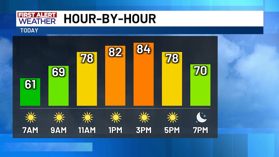
Despite having two cold fronts pushing through, it’ll only be the second cold front that significantly changes the weather. Today’s cold front is mostly a dud, only bringing us a small temperature drop tomorrow morning with a slight increase in northerly winds. We’re out the door this morning in the upper 50s and lower 60s with clear skies overhead. South winds between 5 and 15 MPH this morning will switch to become northerly this afternoon with occasional gusts between 20 and 25 MPH. Despite what’s supposed to be a cold north wind returning, we’re still expecting temperatures to warm up into the low-to-mid 80s this afternoon. For cities and towns near and south of I-14 and Highway 190, highs could even climb into the upper 80s briefly in the afternoon!
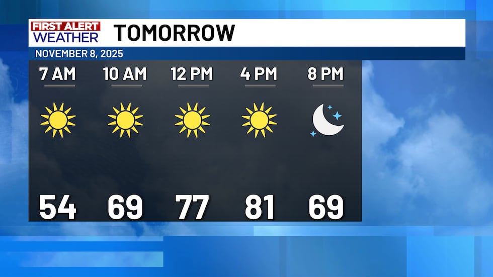
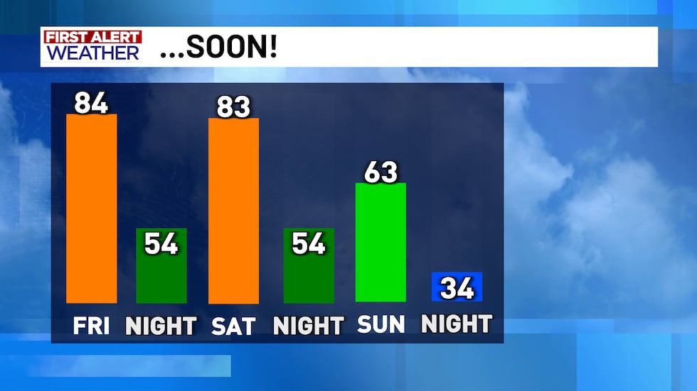
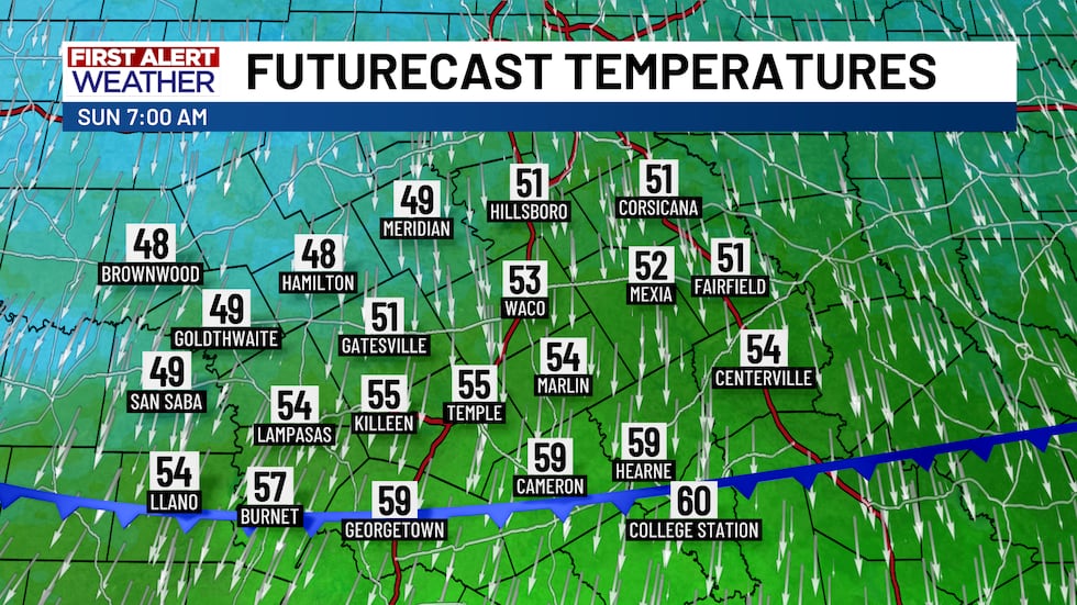
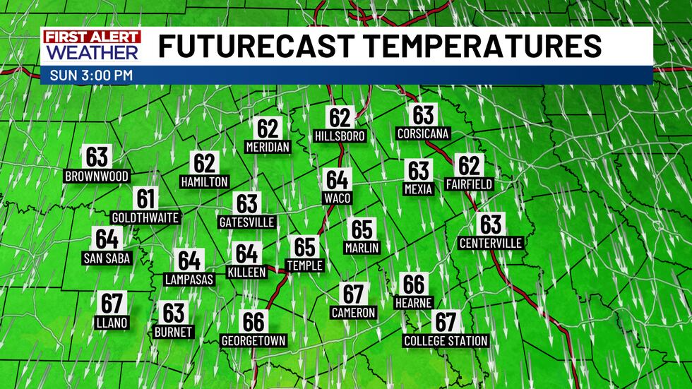
The second cold front technically passes through late Saturday afternoon and evening shifting our winds from the south and west to the north, but the actual push of colder air won’t arrive until the overnight and early morning hours Sunday. Temperatures will really start to tank just around sunrise, so the returning sunshine will stop us from getting too cold Sunday morning. In Bosque, Mills, Hamilton, San Saba, and Hill County, out the door temperatures will be in the upper 40s, but the rest of the area is out the door in the low-to-mid 50s. Technically, it’s a warmer-than-normal morning, but we’re colder-than-average in the afternoon as highs warm only into the low-to-mid 60s! That’s with another day of full sunshine too!
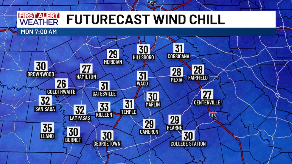
Although Sunday will be a chilly day of weather, it’ll pale in comparison to the coldest air of the season that’ll be in place for Monday! Thankfully, the strong winds Sunday will subside some overnight Sunday into Monday which means wind chills won’t be as low as they potentially could be, but we’re kicking off the new work week with morning temperatures in the low-to-mid 30s being joined by wind chills in the upper 20s! Despite another day of full sunshine, high temperatures Monday should only warm into the mid-to-upper 50s.
We’ll start to claw our way out of the cold weather hole the atmosphere is digging Tuesday, but it’ll still be a cold start to Veterans Day. Out-the-door temperatures in the mid-to-upper 30s will be joined by gusty south winds, so morning wind chills will be in the lower 30s for most. By 9 AM, temperatures will warm into the mid-to-upper 40s, and we’ll warm into the upper 50s around 11 AM. It won’t be awful weather for any Veterans Day celebrations, but you’ll for sure want a jacket if you’re out early, and you’ll want to hang on to your hats throughout the day as south winds gust to near 30 MPH. Temperatures will settle in the upper 60s and low 70s late-day making Tuesday a perfect day for outdoor activities. The warming trend continues from there with temperatures reaching the upper 70s and lower 80s Wednesday through Saturday. Another front could maybe push through late-weekend, but the jury is still out on that. Also still out, the rain chances. The entire first half of the month will feature little to no precipitation. Realistically, our next chance for rain may not arrive for about another two weeks. It could turn a bit soggy around Food For Families time!
Copyright 2025 KWTX. All rights reserved.


