High grass fire danger the only issue with Veterans Day weather
Are y’all ready for some weather whiplash? After the Waco Regional Airport tied a record low Monday morning, we’re quickly leaving the cooler air in the dust! It’s full steam ahead of warmer-than-normal temperatures starting tomorrow which will hang around until when our next storm system pushes in early next week.
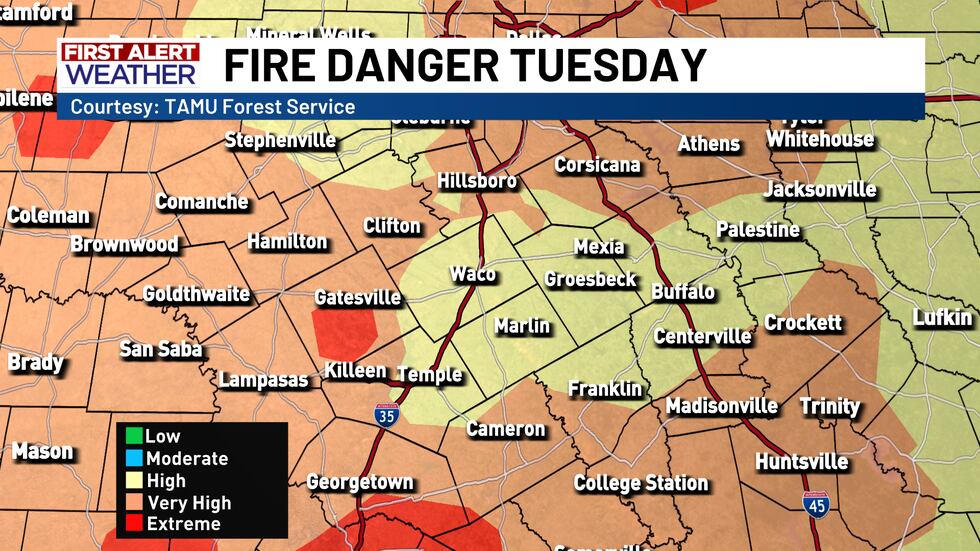
Veterans Day weather will be wonderful, but there is a very high to extreme grass fire danger today across Central Texas! Despite temperatures staying right around average late this afternoon and a chill in the air this morning, very dry air coupled with strong south winds and the recent lack of rain sets up for the elevated fire risk. Yeah, you read that right. South winds are back today just 36 hours removed from that brisk north wind. Today’s south winds will gust as high as 35 MPH, so hang on to your hats! Temperatures this morning starting out in the mid-to-upper 30s will warm into the upper 60s and low 70s late today with full sunshine overhead. The breezy south winds will give us an out-the-door wind chill in the lower 30s. The wind chill will still be in the 40s through mid-morning too. Technically, there’s no wind chill to talk about once the temperature gets about 50°, which should happen just after 9 AM, but it’ll feel brisk outside for much of the day and for today’s Veterans Day parades.

The gusty south winds today will hang around for the remainder of the work week although Tuesday features the highest wind speeds we’ll see. For each day Wednesday through Sunday, expect sustained south winds between 10 and 20 MPH each day with occasional 25 MPH gusts. Temperatures both in the morning and afternoon will warm up. We’re near 50° Wednesday morning out the door, but we’re then jumping into the upper 50s and lower 60s through Monday morning. Afternoon highs will also generally stay in the lower 80s too. The breeze will pull in warmth and humidity ahead of our next storm system. Previously, it looked like that storm system would blow through overnight Saturday into Sunday, but forecast model data is showing a big weather pattern shift that delays our rain chances.
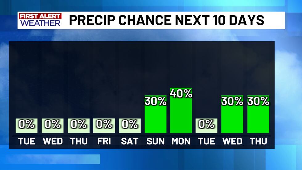
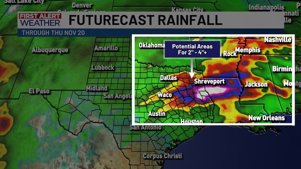
It’s looking more likely than not that we should remain dry through the weekend with maybe some rain arriving late Sunday afternoon into Sunday night. The storm system that was set to move in earlier in the weekend now looks to arrive on Monday. The early week storm system likely drops about a quarter-inch to half-inch of rain and there’s a chance for a stray strong-to-severe thunderstorm depending on when exactly it moves through. For now, I’ve capped the rain chances at 40% on Monday with temperatures dropping into the mid-70s behind Monday’s front. Another and potentially bigger storm system could be on the way mid-to-late week next week and could bring us a few days of rain opportunities. It’s still too far in the future for specifics, but there’s a signal for 1″ to 2″+ across Central and East Texas late next week. As of now, it looks like Wednesday and Thursday may be the best days for rain, but that could easily spill over into Food For Families Friday too.
Copyright 2025 KWTX. All rights reserved.


