August Monthly Outlook And July Retrospective
WACO, Texas (KWTX) - July has come and gone...which means it is time to take a look at the next monthly outlook, courtesy of the Climate Prediction Center! As we will discuss in further detail momentarily, the Summer of 2025 has been unseasonably cool - with a streak of 27 days with afternoon highs below normal in July! This is also due in part to the extra rainfall the month of July featured, with well over 6 inches in total for the month! So - how will the month of August likely look in response to the unseasonably cool and wet summer?
August Precipitation Outlook
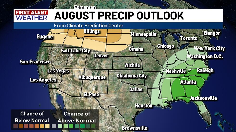
The precipitation (rainfall) outlook for the month of August in Central Texas is pretty much what we would expect - equal chances for above OR below normal rainfall numbers. After what many considered to be a difficult July in terms of predicting rainfall totals, much less seeing how July actually turned out, it is looking a little less likely that the faucet will completely shut off in August. Keep in mind, July is usually the driest month of the year in Central Texas, with an average of 1.82 inches of rainfall in the month...but Central Texas finished with a little over 6 inches. In comparison, August is usually the second driest, just behind July with an average of 2.05 inches in the month, but given how last month played out and the unseasonable weather Central Texas has experienced...we will have to play the waiting game to see how this develops.
Meanwhile, there are two other areas in the nation that are expected to experience the opposite, namely the eastern U.S. and the Pacific Northwest (PNW). In the precipitation outlook, the PNW is expected to have higher chances of BELOW NORMAL precipitation, while the eastern U.S. is expected to have above normal rainfall totals in August, most likely due to an uptick in tropical activity for the month.
August Temperature Outlook
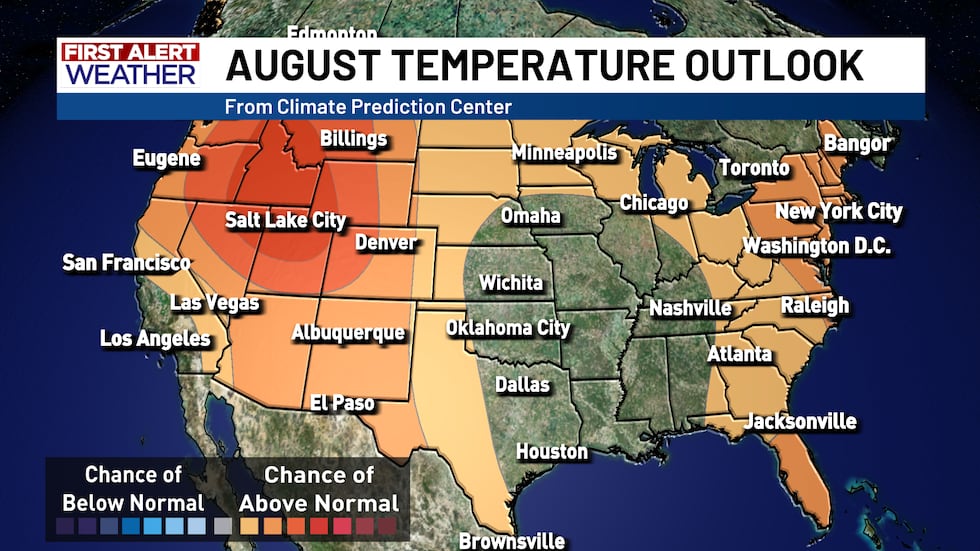
When it comes to the temperatures in Central Texas going into August, it is more of the same - equal chances for above or below normal temperatures. Yes, August is usually the hottest month of the year, with an average afternoon high temperature of 97.1° Fahrenheit, which no other month can lay claim to (at least in Central Texas). However, as mentioned before, despite how hot July was, the majority of the afternoon highs stayed several degrees below normal. It is not out of the realm of possibility to see something similar take shape in August, but it is also possible that we could see a return to the norm, with temperatures getting back into the upper 90’s more regularly.
While the eastern U.S. and part of the Great Lakes region is expecting a chance at above normal temperatures, the odds there are not quite as high as the odds in the Pacific Northwest (PNW). In the last section we discussed that the PNW is expected less rainfall in August...and this is the reason why. Above normal temperatures, while not a given, are still expected across much of the northwestern U.S. in places like Idaho, Utah, Montana, and Washington state. August is usually peak wildfire season for the PNW, so this will be worth keeping tabs on, especially if the PNW sees lower than normal rainfall in August.
Copyright 2025 KWTX. All rights reserved.


