What Is The El Niño Southern Oscillation? How Does It Work?
A Detailed Breakdown of ENSO
You may have heard of El Niño and La Niña before, but what exactly are they? El Niño and La Niña are two of the three different phases of what is called the El Niño Southern Oscillation, or ENSO. ENSO can have large impacts on our long term weather and forecasting, with the effects especially felt during the winter season across the northern hemisphere. So, how does ENSO work? Lets break it down into the three phases to get an understanding.
El Niño
El Niño is the first of the three phases of ENSO. El Niño occurs when the trade winds that are located over the equatorial/tropical Pacific weaken. On any given normal day, these trade winds usually help to push warmer waters from east to west across the Pacific basin, essentially from the west coast of the Americas to near Asia. However, when these trade winds weaken, the warmer waters don’t move, and stay near the west coast of the Americas as a result. This leads to the El Niño phase - the warmer waters effect the state of the atmosphere above, creating an amplified Pacific jet stream that extends across the southern half of the contiguous United States. This leads to wetter and slightly cooler than average conditions across the southern half of the U.S. with warmer than normal and drier than normal conditions to the north in the wintertime.
La Niña
La Niña, the second phase of ENSO, is essentially the opposite of El Niño. The same trade winds try to push warmer waters from east to west across the equatorial Pacific, but instead of weakening, this time, they strengthen. This leads to not just warmer waters near Asia, but the upwelling of much cooler waters near the Americas. As a result, the Pacific jet stream is pushed much further to the north, leading to wetter and cooler conditions across the northern U.S. and Canada. Meanwhile, the southern U.S. and the Gulf coast usually sees warmer and drier than normal conditions.
ENSO Neutral
ENSO Neutral is exactly how it sounds - it is the neutral phase (or a transition phase) between El Niño and La Niña, meaning it is neither and is it’s own phase. During an ENSO Neutral phase, the water temperatures in the Pacific are at or near average. This phase occurs when the atmosphere is between either El Niño or La Niña, and usually leads to variable and less predictable weather.
How Is ENSO Measured?
ENSO is measured by using a parameter called the Oceanic Niño Index (ONI). To calculate ONI, the National Weather Service uses the 30 year average of the sea surface temperatures in the Niño region (which is essentially an area in the tropical Pacific that is used to monitor ENSO) and compares them to the three month long averages (aka, more current averages) of the sea surface temperatures in the same region. If the three month average is 0.5° Celsius warmer than the 30 year average, that is indicative of an El Niño phase. If the three month average is 0.5° Celsius cooler than the 30 year average, that is indicative of a La Niña phase. If the three month average is in between -0.5° Celsius and +0.5° Celsius when compared to the 30 year average, this is neither El Niño or La Niña - it is the neutral phase! Below is a visual representation of what this looks like on a graph thanks to Golden Gate Weather Services:
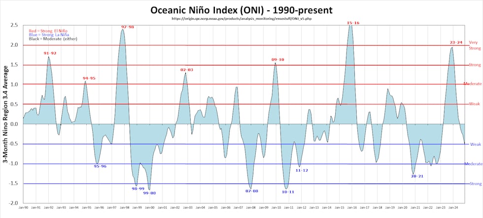
Historical El Niño and La Niña Phases
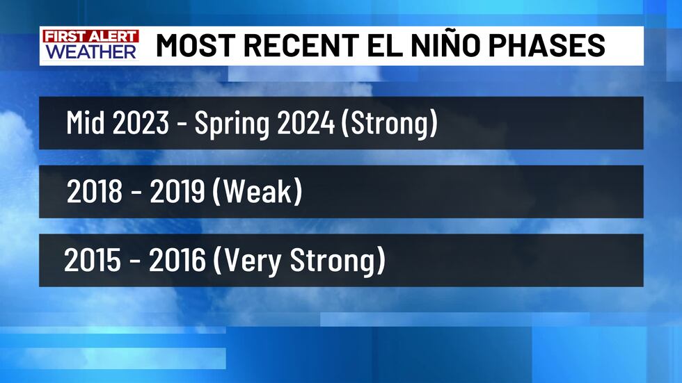
As you can probably tell by the graph above, there have been a number of El Niño and La Niña phases in the last several years. The most recent El Niño phase occurred from Mid 2023 until Spring 2024. This was a stronger El Niño phase, with an ONI value nearly +2.0° Celsius above the 30 year average at its peak. Prior to 2023, there was another, much weaker El Niño phase from 2018 to 2019. The strongest El Niño phase in the last decade happened from 2015 to 2016, with an ONI of +2.5° Celsius or greater at the cycle’s peak.
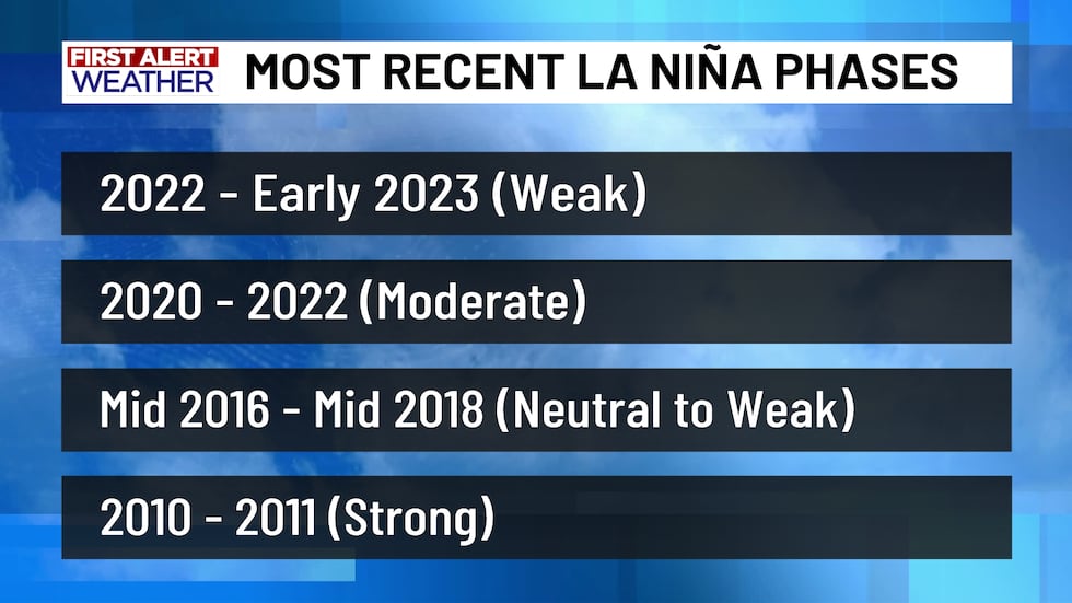
On the other hand, the most recent La Niña phases happened as recently as 2020 to early 2023, varying from a weak to moderate La Niña. A weaker La Niña phase also occurred from mid 2016 to mid 2018, which followed the strongest La Niña phase in quite a while - 2010 to 2011. Many Central Texans will remember how hot and dry the summer of 2011 was, keeping in line with what the southern U.S. usually sees during a La Niña phase. In fact, based on the data kept at the Waco Regional Airport, the summer of 2011 is the hottest summer on record (when it comes to average temperatures and high temperatures) in Central Texas thus far.
So, Where Are We Now?
In mid to late 2025, we are in the ENSO Neutral Phase - so neither El Niño or La Niña. However, the Climate Prediction Center (CPC) is anticipating a transition into a La Niña phase as we enter the Fall season. Based on their ENSO Diagnostic Discussion, the CPC suggests a 71% chance of La Niña conditions during September, October, and November, with a 54% chance of these La Niña conditions continuing into the winter.
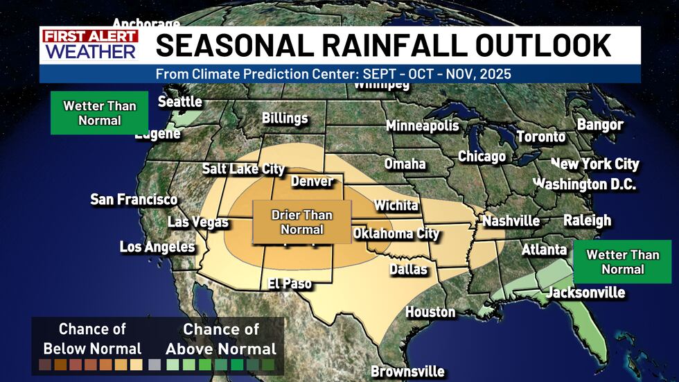
You can clearly see that the seasonal outlook from the CPC aligns with these expected La Niña conditions. Drier than normal conditions are expected across much of the southern U.S. while the Pacific Northwest is anticipating higher than normal rainfall amounts. The same can be said for Florida and parts of the east coast - but this is largely because of hurricane season, not necessarily La Niña conditions. In fact, there is some research that suggests that La Niña conditions favor a more active hurricane season in the Atlantic basin, so we will have to wait and see what results from this if La Niña takes shape in a short time.
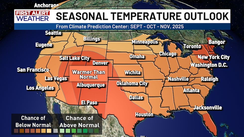
Meanwhile, the Fall temperature outlook is also keeping somewhat in line with the anticipated shift to La Niña. While the southern U.S. is drier, it is also expected to be warmer, with the northern U.S. and Canada seeing equal chances of near normal temperatures. So - if you are in Central Texas - take this with a grain of salt as the weather is ALWAYS changing, but based on what the Climate Prediction Center is expecting, you *could* see a slightly warmer and drier Fall season ahead!
Copyright 2025 KWTX. All rights reserved.


